
Butterfly Monitoring Scheme
MacGregor Park Leads the Way
MacGregor Provincial Park was the first park to participate in the Ministry of Natural Resources Butterfly Monitoring Scheme. Largely due to the success of the survey in our park the program has been expanded into an additional 20 provincial parks in 2026.
Why Monitor Butterflies?
Changes in landscape and climate are rapidly transforming plant and animal communities. Monitoring long-term changes in these communities can help us understand the impact of stressors and identify species and populations that are most vulnerable. Our aim is to use community-science butterfly monitoring to connect people with nature while producing high quality data on changes in butterfly abundance that can help inform conservation.
How Does Monitoring Work?
Monitoring changes in butterfly abundance and flight period is done using transect counts, also known as Pollard walks. Volunteers walk fixed routes 1 to 1.5 km in length, weekly from April to September each year to record butterfly numbers and species. Each route is divided into sections that represent different habitat types. This type of monitoring requires a regular commitment from volunteers, who are asked to walk the same route once a week during the active butterfly season.
What we Discovered in 2025!
In 2025 along the Tower Trail Transect we identified 30 species and 457 individual butterflies over our 23 walks. The Harvester Butterfly has been seen more often in Ontario and three were spotted in MacGregor Park in 2025. The last time this butterfly was identified in Bruce County was 12 years ago. The Ontario Butterfly Monitoring Survey (OBMS) has the observations from MacGregor Provincial Park on page 14.

2026 Transect for Tower Trail
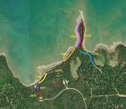
2026 Transect for Old Shore Road